
Obrigado por apoiar este site ❤️
Faça uma doação
Faça uma doação
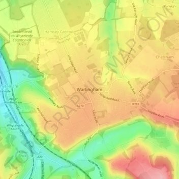
Mapa topográfico Warlingham
Clique no mapa para exibir a altitude.
Obrigado por apoiar este site ❤️
Faça uma doação
Faça uma doação
Warlingham
Elevations vary from 110m AOD at Woldingham Road, at the southernmost point of the parish, with a gentle increase in height through the village along the main road heading to the southeast, to the highest elevation (199.6m) at Limpsfield Road.
Obrigado por apoiar este site ❤️
Faça uma doação
Faça uma doação
Sobre este mapa
Nome: Mapa topográfico Warlingham, altitude, relevo.
Local: Warlingham, Tandridge, Surrey, England, United Kingdom (51.29627 -0.08224 51.32273 -0.03045)
Altitude média: 163 m
Altitude mínima: 90 m
Altitude máxima: 224 m
Obrigado por apoiar este site ❤️
Faça uma doação
Faça uma doação