
Mapa topográfico Vaihingen an der Enz
Mapa interativo
Clique no mapa para exibir a altitude.
Vaihingen an der Enz
Vaihingen lies at an altitude of 200 to 450 metres at the end of the Strohgäus, on the western edge of the Neckarbecken in a valley widening of the Enz. The town centre lies on the east side of the river and is overlooked by the castle Kaltenstein.
Sobre este mapa
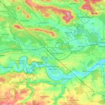
Nome: Mapa topográfico Vaihingen an der Enz, altitude, relevo.
Altitude média: 283 m
Altitude mínima: 189 m
Altitude máxima: 475 m