
Faça uma doação
Mapa topográfico Cauterets
Clique no mapa para exibir a altitude.
Faça uma doação
Cauterets
The minimum altitude, 503 metres (1,650 ft), is located in the north, where the Gave de Cauterets leaves the communal area and enters that of Soulom. The maximum elevation of 3,298 metres (10,820 ft) corresponds to the highest point of the French Pyrénées, Vignemale, marking the border with Spain [fr]. Other summits in the neighbourhood include the Monné at 2,723 metres (8,934 ft), the Cabaliros at 2,333 metres (7,654 ft) and the Pic de Chabarrou at 2,910 metres (9,550 ft).
Faça uma doação
Sobre este mapa
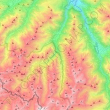
Nome: Mapa topográfico Cauterets, altitude, relevo.
Altitude média: 1.817 m
Altitude mínima: 466 m
Altitude máxima: 3.265 m
Faça uma doação
Outros mapas topográficos
Clique em um mapa para visualizar sua topografia, sua altitude e seu relevo.
Luz-Saint-Sauveur
France > Occitania > Hautes Pyrenees > Luz-Saint-Sauveur > Luz-Saint-Sauveur
Altitude média: 1.035 m
Faça uma doação
Faça uma doação
Cazaux-Debat
France > Occitania > Hautes Pyrenees > Cazaux-Fréchet-Anéran-Camors
Altitude média: 1.324 m