Mapa topográfico Charleshill
Clique no mapa para exibir a altitude.
Sobre este mapa
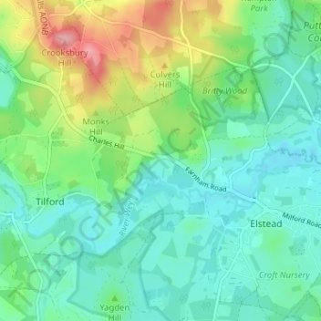
Nome: Mapa topográfico Charleshill, altitude, relevo.
Altitude média: 73 m
Altitude mínima: 41 m
Altitude máxima: 155 m

Clique no mapa para exibir a altitude.
Nome: Mapa topográfico Charleshill, altitude, relevo.
Altitude média: 73 m
Altitude mínima: 41 m
Altitude máxima: 155 m