
Mapa topográfico Belmopan
Mapa interativo
Clique no mapa para exibir a altitude.
Belmopan
Belmopan is located in Cayo District at an altitude of 76 metres (249 feet) above sea level. Belmopan was constructed just to the east of the Belize River, 80 km (50 mi) inland from the former capital, the port of Belize City, after that city's near destruction by Hurricane Hattie in 1961. The government was moved to Belmopan in 1970. Its National Assembly Building is designed to resemble a Pre-Columbian Maya temple.
Sobre este mapa
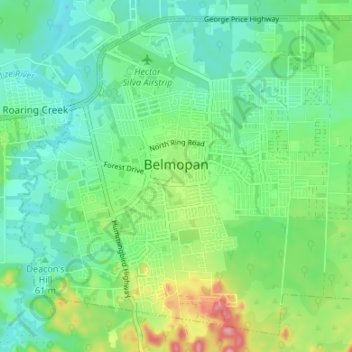
Nome: Mapa topográfico Belmopan, altitude, relevo.
Local: Belmopan, Cayo District, Belize (17.21909 -88.79964 17.27678 -88.73276)
Altitude média: 61 m
Altitude mínima: 22 m
Altitude máxima: 156 m
Outros mapas topográficos
Clique em um mapa para visualizar sua topografia, sua altitude e seu relevo.