
Faça uma doação
Mapa topográfico Bury St Edmunds
Clique no mapa para exibir a altitude.
Faça uma doação
Bury St Edmunds
The name Bury is etymologically connected with borough, which has cognates in other Germanic languages such as German Burg 'fortress, castle' and Old Norse borg 'wall, castle'; and Gothic baurg 'city'. They all derive from Proto-Germanic *burgs 'fortress'. This in turn derives from the Proto-Indo-European root *bhrgh 'fortified elevation', with cognates including Welsh bera 'stack' and Sanskrit bhrant- 'high, elevated building'. In Medieval Latin it was known as Burgum Sancti Edmundi (also spelled Aedmundi). In the Anglo-Saxon period the town was called Bedricesweord or Bedericesworth.
Faça uma doação
Sobre este mapa
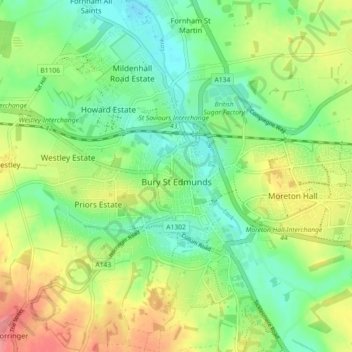
Nome: Mapa topográfico Bury St Edmunds, altitude, relevo.
Local: Bury St Edmunds, West Suffolk, Suffolk, England, United Kingdom (52.22234 0.67387 52.27133 0.76382)
Altitude média: 54 m
Altitude mínima: 24 m
Altitude máxima: 98 m
Faça uma doação
Outros mapas topográficos
Clique em um mapa para visualizar sua topografia, sua altitude e seu relevo.
Faça uma doação
Faça uma doação
Faça uma doação
Faça uma doação
Lower Green
United Kingdom > England > Suffolk > West Suffolk > Higham > Lower Green
Altitude média: 67 m
Blackthorpe
United Kingdom > England > Suffolk > West Suffolk > Rougham > Blackthorpe
Altitude média: 63 m
Faça uma doação