
Obrigado por apoiar este site ❤️
Faça uma doação
Faça uma doação
Mapa topográfico Atlantic Beach
Clique no mapa para exibir a altitude.
Obrigado por apoiar este site ❤️
Faça uma doação
Faça uma doação
Sobre este mapa
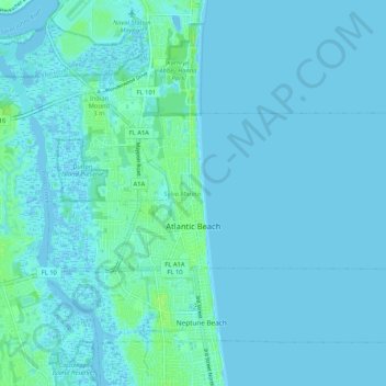
Nome: Mapa topográfico Atlantic Beach, altitude, relevo.
Local: Atlantic Beach, Duval County, Florida, 32233, United States (30.32343 -81.43873 30.36103 -81.33418)
Altitude média: 2 m
Altitude mínima: -4 m
Altitude máxima: 10 m
Obrigado por apoiar este site ❤️
Faça uma doação
Faça uma doação
Outros mapas topográficos
Clique em um mapa para visualizar sua topografia, sua altitude e seu relevo.
Jacksonville
United States > Florida > Duval County > Jacksonville
Just south of Jacksonville and north of Saint Augustine is the boundary of where the Floridian Peninsula ends and Continental North America begins; Jacksonville is north of that line. While still in the North American Coastal plain, the topography begins to take on slight Piedmont characteristics. Like the…
Altitude média: 9 m