
Faça uma doação
Mapa topográfico Murray
Clique no mapa para exibir a altitude.
Faça uma doação
Murray
According to the United States Census Bureau, the city has a total area of 9.6 square miles (25 km2), all land. Murray is located in the heart of the Salt Lake Valley. The city is nearly built out with a broad mix of commercial, residential and industrial uses. The topography is generally gentle, sloping westward from the nearby Wasatch Mountain Range toward the Jordan River, which is the terminal river feature in the Salt Lake Valley. Murray's average altitude is approximately 1300 meters above sea level, with the highest variation located near the border of Cottonwood Heights and lowest variation along the Jordan River near 4500 South.
Faça uma doação
Sobre este mapa
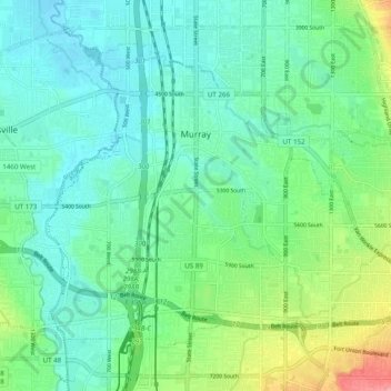
Nome: Mapa topográfico Murray, altitude, relevo.
Local: Murray, Salt Lake County, Utah, United States (40.62614 -111.93207 40.68390 -111.83411)
Altitude média: 1.321 m
Altitude mínima: 1.293 m
Altitude máxima: 1.403 m
Faça uma doação
Outros mapas topográficos
Clique em um mapa para visualizar sua topografia, sua altitude e seu relevo.
Jordan River OHV/ Modelport State Park
United States > Utah > Salt Lake County > Salt Lake City
Altitude média: 1.286 m
Faça uma doação
Faça uma doação
Salt Lake City
United States > Utah > Salt Lake County > Salt Lake City
Salt Lake City has an area of 110.4 square miles (286 km2) and an average elevation of 4,327 feet (1,319 m) above sea level. The lowest point within the boundaries of the city is 4,210 feet (1,280 m) near the Jordan River and the Great Salt Lake, and the highest is Grandview Peak, at 9,410 feet (2,868 m).
Altitude média: 1.625 m
Faça uma doação
Faça uma doação
Faça uma doação
Meridian Peak
United States > Utah > Salt Lake County > Salt Lake City
Meridian Peak can be found at the southern end of Elliot Ridge Trail. It can be reached by ascending several hiking trails into the Gore Range. Surprise Lake Trail goes south for 2.6 miles to Surprise Lake, then the Gore Range Trail continues west for 1.9 miles to a junction with the Upper Cataract Lake and…
Altitude média: 1.698 m
Faça uma doação
Brighton
United States > Utah > Salt Lake County
Brighton has a high-altitude cold continental climate (Köppen Dsb/Dsc), with dry summers and very snowy winters.
Altitude média: 2.852 m
Faça uma doação