
Mapa topográfico Heiligenwald
Mapa interativo
Clique no mapa para exibir a altitude.
Sobre este mapa
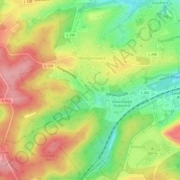
Nome: Mapa topográfico Heiligenwald, altitude, relevo.
Altitude média: 329 m
Altitude mínima: 264 m
Altitude máxima: 392 m
Outros mapas topográficos
Clique em um mapa para visualizar sua topografia, sua altitude e seu relevo.
Stennweiler
Deutschland > Saarland > Landkreis Neunkirchen > Schiffweiler
Stennweiler, Schiffweiler, Landkreis Neunkirchen, Saarland, Deutschland
Altitude média: 353 m
Landsweiler-Reden
Deutschland > Saarland > Landkreis Neunkirchen > Schiffweiler
Landsweiler-Reden, Schiffweiler, Landkreis Neunkirchen, Saarland, Deutschland
Altitude média: 303 m
Stennweiler
Deutschland > Saarland > Landkreis Neunkirchen > Schiffweiler > Stennweiler
Stennweiler, Schiffweiler, Landkreis Neunkirchen, Saarland, 66578, Deutschland
Altitude média: 342 m