
Faça uma doação
Mapa topográfico El Cerrito
Clique no mapa para exibir a altitude.
Faça uma doação
El Cerrito
According to the United States Census Bureau, the city has a total area of 3.7 square miles (9.6 km2), all of it land. The city ranges in elevation from 20 to 934 feet, with an average elevation of 69 feet (21 m).
Faça uma doação
Sobre este mapa
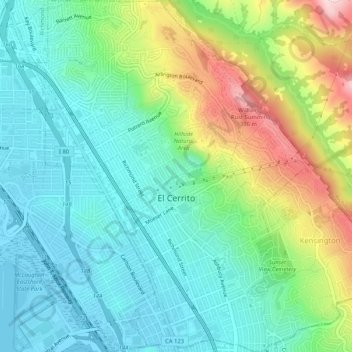
Nome: Mapa topográfico El Cerrito, altitude, relevo.
Altitude média: 91 m
Altitude mínima: -1 m
Altitude máxima: 307 m
Faça uma doação
Outros mapas topográficos
Clique em um mapa para visualizar sua topografia, sua altitude e seu relevo.
Contra Costa Centre
United States > California > Contra Costa County
Contra Costa Centre is an unincorporated community and census-designated place in Contra Costa County, California. Contra Costa Centre sits at an elevation of 92 feet (28 m). The 2010 United States census reported Contra Costa Centre's population was 5,364, while the 2020 census figure was 6,808. Contra Costa…
Altitude média: 36 m
Faça uma doação
Faça uma doação
Faça uma doação
Lafayette Reservoir
United States > California > Contra Costa County > Lafayette
Altitude média: 174 m
Saranap
United States > California > Contra Costa County
Saranap (until 1913, Dewing Park) is a residential census-designated place (CDP) within central Contra Costa County, California. Lying at an elevation of 180 feet (55 m), it is bounded on the south and east by portions of Walnut Creek (including the gated senior residential development Rossmoor) and on the…
Altitude média: 92 m
Faça uma doação
Faça uma doação
Faça uma doação
Faça uma doação
Crolona Heights
United States > California > Contra Costa County > Crockett > Crolona Heights
Altitude média: 61 m
Faça uma doação