
Mapa topográfico Pink
Mapa interativo
Clique no mapa para exibir a altitude.
Sobre este mapa
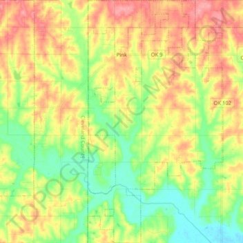
Nome: Mapa topográfico Pink, altitude, relevo.
Local: Pink, Pottawatomie County, Oklahoma, United States (35.15967 -97.14222 35.28971 -97.05342)
Altitude média: 324 m
Altitude mínima: 285 m
Altitude máxima: 370 m
The 1891 Oklahoma and Indian Territories map portrays Shawneetown (Shawnee) as the only settlement north of Little River in the future Pottawatomie County. Pink appears later on Cram's 1898 Oklahoma and Indian Territory Map.] Topographic mapping of Pink and Pottawatomie County began sometime after 1903. Pink School was built sometime prior to its depiction on the 1910 McComb Quadrangle at the northwest corner of Section 28, Brinton Township (now corner of Okay Rd and Willow View Rd).