
Faça uma doação
Mapa topográfico Red Hill
Clique no mapa para exibir a altitude.
Faça uma doação
Sobre este mapa
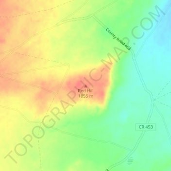
Nome: Mapa topográfico Red Hill, altitude, relevo.
Local: Red Hill, Apache County, Arizona, United States (35.98968 -109.76016 35.98978 -109.76006)
Altitude média: 1.830 m
Altitude mínima: 1.803 m
Altitude máxima: 1.856 m
Faça uma doação
Outros mapas topográficos
Clique em um mapa para visualizar sua topografia, sua altitude e seu relevo.
Window Rock
United States > Arizona > Apache County
Window Rock is categorized as being within the 6a USDA hardiness zone, meaning the average annual extreme minimum temperature is between −10 and −5 °F (−23 and −21 °C). The city is cooler than most of Arizona due to its high elevation.
Altitude média: 2.084 m
Petrified Forest National Park
United States > Arizona > Apache County
Averaging about 5,400 feet (1,600 m) in elevation, the park has a dry windy climate with temperatures that vary from summer highs of about 100 °F (38 °C) to winter lows well below freezing. More than 400 species of plants, dominated by grasses such as bunchgrass, blue grama, and sacaton, are found in the…
Altitude média: 1.722 m
Faça uma doação
Alpine
United States > Arizona > Apache County > Alpine
Located approximately 75 miles south of the Navajo Nation, Alpine was settled in 1876 by Anderson Bush, a European-American who built a log house there. He originally used it as a trading post known as "Fort Bush". Bush sold his holdings in 1879 to William Maxwell and Fred Hamblin, Mormon settlers who…
Altitude média: 2.465 m
McNary
United States > Arizona > Apache County
At an elevation of 7,316 feet (2,230 m), it is the second highest community in Arizona after Alpine.
Altitude média: 2.240 m
Petrified Forest National Park
United States > Arizona > Apache County
Averaging about 5,400 feet (1,600 m) in elevation, the park has a dry windy climate with temperatures that vary from summer highs of about 100 °F (38 °C) to winter lows well below freezing. More than 400 species of plants, dominated by grasses such as bunchgrass, blue grama, and sacaton, are found in the…
Altitude média: 1.722 m
Faça uma doação
Springerville
United States > Arizona > Apache County
Springerville sits at an elevation of 6,907 feet (2,105 m) above sea level. Along with its neighbor Eagar, the communities make up the place known as Round Valley, which is in the central-eastern part of Arizona close to the New Mexico border.
Altitude média: 2.150 m
Faça uma doação