
Mapa topográfico Mississippi River
Mapa interativo
Clique no mapa para exibir a altitude.
Sobre este mapa
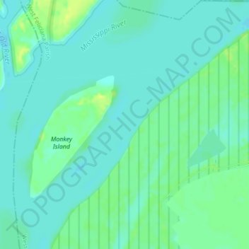
Nome: Mapa topográfico Mississippi River, altitude, relevo.
Altitude média: 13 m
Altitude mínima: 7 m
Altitude máxima: 24 m
The uppermost lock and dam on the Upper Mississippi River is the Upper St. Anthony Falls Lock and Dam in Minneapolis. Above the dam, the river's elevation is 799 feet (244 m). Below the dam, the river's elevation is 750 feet (230 m). This 49-foot (15 m) drop is the largest of all the Mississippi River locks and dams. The origin of the dramatic drop is a waterfall preserved adjacent to the lock under an apron of concrete. Saint Anthony Falls is the only true waterfall on the entire Mississippi River. The water elevation continues to drop steeply as it passes through the gorge carved by the waterfall.
Outros mapas topográficos
Clique em um mapa para visualizar sua topografia, sua altitude e seu relevo.
Tunica Hills
United States > Louisiana > West Feliciana Parish
Tunica Hills, West Feliciana Parish, Louisiana, 70782, United States
Altitude média: 53 m
St. Francisville
United States > Louisiana > West Feliciana Parish
St. Francisville, West Feliciana Parish, Louisiana, United States
Altitude média: 39 m