
Faça uma doação
Mapa topográfico Allen
Clique no mapa para exibir a altitude.
Faça uma doação
Sobre este mapa
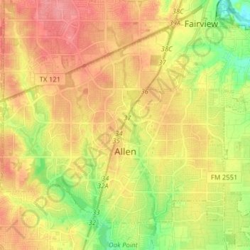
Nome: Mapa topográfico Allen, altitude, relevo.
Local: Allen, Collin County, Texas, United States (33.07079 -96.73667 33.15801 -96.60899)
Altitude média: 200 m
Altitude mínima: 159 m
Altitude máxima: 233 m
Faça uma doação
Outros mapas topográficos
Clique em um mapa para visualizar sua topografia, sua altitude e seu relevo.
Faça uma doação
Frisco
United States > Texas > Collin County > Frisco
When the Dallas area was being settled by American pioneers, many of the settlers traveled by wagon trains along the Shawnee Trail. This trail became the Preston Trail, and later, Preston Road. With all of this activity, the community of Lebanon was founded along this trail, and was granted a U.S. post office…
Altitude média: 191 m
Faça uma doação
Faça uma doação
Plano
United States > Texas > Collin County > Plano
At first, Plano's population grew slowly, reaching 1,304 in 1900 and 3,695 in 1960. By 1970, Plano began to feel some of the boom its neighbors had experienced after World War II. A series of public works projects and a change in taxes that removed the farming community from the town helped increase the…
Altitude média: 181 m