
Mapa topográfico Tolox
Mapa interativo
Clique no mapa para exibir a altitude.
Sobre este mapa
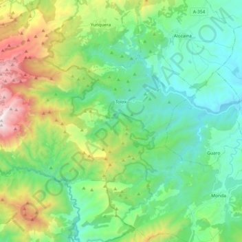
Nome: Mapa topográfico Tolox, altitude, relevo.
Local: Tolox, Sierra de las Nieves, Malaga, Andalusia, 29109, Spain (36.63482 -5.03071 36.71629 -4.84617)
Altitude média: 608 m
Altitude mínima: 120 m
Altitude máxima: 1.901 m
Tolox is a town and municipality in the province of Málaga in the autonomous community of Andalusia in southern Spain. The municipality has a population of 2,317 (2006). It is situated in the centre of the Sierra de las Nieves Nature Park at the foot of the Sierra Blanca and the Sierra Parda. In addition to La Torrecilla peak (1,919 m.), there are ancient woodlands of Spanish Fir and gall oak. The municipality covers 94 km2, has a mean elevation of 285 m. and mean geographical coordinates of 36° 41' 11" N, 4° 54' 16" E. The channel of the Rio Grande flows through the town from northeast to south.
Outros mapas topográficos
Clique em um mapa para visualizar sua topografia, sua altitude e seu relevo.
Guaro
Spain > Andalusia > Sierra de las Nieves
Guaro, Sierra de las Nieves, Malaga, Andalusia, 29108, Spain
Altitude média: 259 m
Sierra Real
Spain > Andalusia > Sierra de las Nieves > Istán
Sierra Real, Istán, Sierra de las Nieves, Malaga, Andalusia, Spain
Altitude média: 993 m
Ojén
Spain > Andalusia > Sierra de las Nieves
Ojén, Sierra de las Nieves, Malaga, Andalusia, 29610, Spain
Altitude média: 404 m