
Faça uma doação
Mapa topográfico Tauplitz
Clique no mapa para exibir a altitude.
Faça uma doação
Sobre este mapa
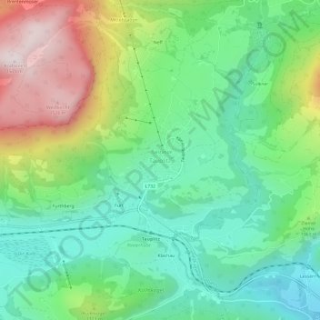
Nome: Mapa topográfico Tauplitz, altitude, relevo.
Altitude média: 1.010 m
Altitude mínima: 731 m
Altitude máxima: 1.559 m
Faça uma doação
Outros mapas topográficos
Clique em um mapa para visualizar sua topografia, sua altitude e seu relevo.
Faça uma doação
Grundlsee
Austria > Styria > Bezirk Liezen
The climate in Grundlsee is determined by its geographical location in the Aussee Basin. It is characterized mainly by the high altitude and the location in the northern congestion area. The result is, in the case of flow conditions from the west to the north, often days of precipitation, which in winter are…
Altitude média: 1.240 m
Ramsau am Dachstein
Austria > Styria > Bezirk Liezen
Ramsau am Dachstein is situated between the Dachstein range of mountains in the north and the Enns valley in the south. While the Dachstein range contains peaks up to 2,995 m (9,826 ft) and the towns of the Enns valley, such as Schladming, lie at around 700 m (2,300 ft) above sea level, the Ramsau plateau is a…
Altitude média: 1.526 m
Faça uma doação
Faça uma doação