
Faça uma doação
Mapa topográfico Santa Cruz
Clique no mapa para exibir a altitude.
Faça uma doação
Sobre este mapa
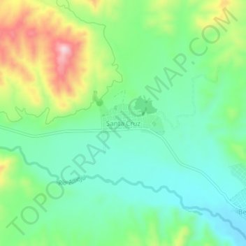
Nome: Mapa topográfico Santa Cruz, altitude, relevo.
Local: Santa Cruz, Bellavista, Province of Jaén, Cajamarca, Peru (-5.67108 -78.72040 -5.63108 -78.68040)
Altitude média: 511 m
Altitude mínima: 419 m
Altitude máxima: 702 m
Faça uma doação
Outros mapas topográficos
Clique em um mapa para visualizar sua topografia, sua altitude e seu relevo.
Faça uma doação
Province of San Miguel
The San Miguel Province is one of the thirteen provinces in the Cajamarca Region of Peru. It was created by Law No. 15152 on September 29, 1964 by president Fernando Belaunde Terry. It has a mountainous territory which varies in height from 500 to more than 4,000 metres (1,600–13,000 ft) above sea level. As…
Altitude média: 2.197 m
Province of Santa Cruz
The province of Santa Cruz's land area is 1,423 km2, 4.2% of the total of the Cajamarca Region. It is mostly mountainous in relief. It is located on the Western Mountain range of the Andes and is bounded by the mountains that descend to the coast and the deep rivers that carve the mountains. Its lowest…
Altitude média: 2.323 m
Faça uma doação
Faça uma doação
Province of Santa Cruz
Santa Cruz Province's land area is 1,423 km2, 4.2% of the total of the Cajamarca Region. It is mostly mountainous in relief. It is located on the Western Mountain range of the Andes and is bounded by the mountains that descend to the coast and the deep rivers that carve the mountains. Its lowest elevation is…
Altitude média: 2.323 m
Faça uma doação