
Faça uma doação
Mapa topográfico Lavamünd
Clique no mapa para exibir a altitude.
Faça uma doação
Lavamünd
Lavamünd lies in the southeast of Carinthia, close to the border with Slovenia (Slovene Carinthia). It is situated at the confluence of the Lavant and Drava rivers. In the northeast, the Soboth Pass leads across the Koralpe range to Eibiswald in Styria. At an elevation of 348 m (1,142 ft) AA, the area is the lowest part of Carinthia.
Faça uma doação
Sobre este mapa
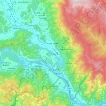
Nome: Mapa topográfico Lavamünd, altitude, relevo.
Local: Lavamünd, Bezirk Wolfsberg, Carinthia, 9473, Austria (46.60140 14.85436 46.72871 15.06515)
Altitude média: 768 m
Altitude mínima: 326 m
Altitude máxima: 1.688 m
Faça uma doação
Outros mapas topográficos
Clique em um mapa para visualizar sua topografia, sua altitude e seu relevo.
Hintergumitsch
Austria > Carinthia > Bezirk Wolfsberg > Frantschach-Sankt Gertraud
Altitude média: 662 m
Schiefling
Austria > Carinthia > Bezirk Wolfsberg > Bad Sankt Leonhard im Lavanttal
Altitude média: 849 m
Wartkogel
Austria > Carinthia > Bezirk Wolfsberg > Bad Sankt Leonhard im Lavanttal
Altitude média: 964 m
Faça uma doação