
Obrigado por apoiar este site ❤️
Faça uma doação
Faça uma doação
Mapa topográfico Taplejung
Clique no mapa para exibir a altitude.
Obrigado por apoiar este site ❤️
Faça uma doação
Faça uma doação
Taplejung
Geographically Taplejung is a mountainous district where the world's third highest peak Kanchenjunga (8586 m) is located. It is situated at elevation ranging from 670 metres (2,200 ft) to 8,586 metres (28,169 ft) from sea level.
Obrigado por apoiar este site ❤️
Faça uma doação
Faça uma doação
Sobre este mapa
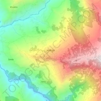
Nome: Mapa topográfico Taplejung, altitude, relevo.
Local: Taplejung, Phungling, Taplejung, Koshi Province, 57500, Nepal (27.31870 87.63273 27.39870 87.71273)
Altitude média: 1.410 m
Altitude mínima: 556 m
Altitude máxima: 2.666 m
Obrigado por apoiar este site ❤️
Faça uma doação
Faça uma doação
Outros mapas topográficos
Clique em um mapa para visualizar sua topografia, sua altitude e seu relevo.