
Mapa topográfico Victoria Peak Lookout (over the Victoria Harbour)
Mapa interativo
Clique no mapa para exibir a altitude.
Sobre este mapa
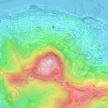
Nome: Mapa topográfico Victoria Peak Lookout (over the Victoria Harbour), altitude, relevo.
Altitude média: 191 m
Altitude mínima: -2 m
Altitude máxima: 534 m
Outros mapas topográficos
Clique em um mapa para visualizar sua topografia, sua altitude e seu relevo.
扯旗山 Victoria Peak
China > Hongkong > Hong Kong Island
扯旗山 Victoria Peak, Hong Kong Island, Hongkong, China
Altitude média: 209 m
Southern District
China > Hongkong > Hong Kong Island
Southern District, Hong Kong Island, Hongkong, China
Altitude média: 36 m
中區 Central District
China > Hongkong > Hong Kong Island
中區 Central District, Hong Kong Island, Hongkong, China
Altitude média: 114 m