
Mapa topográfico Stanthorpe
Clique no mapa para exibir a altitude.
Stanthorpe
Owing to its elevation, Stanthorpe features a subtropical highland climate. At an altitude of 811 metres (2,661 ft), Stanthorpe holds the record for the lowest temperature recorded in Queensland at −10.6 °C (12.9 °F) on 23 June 1961. Sleet and light snowfalls are occasionally recorded, with the most significant snowfall in over 30 years occurring on 17 July 2015.
Sobre este mapa
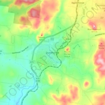
Nome: Mapa topográfico Stanthorpe, altitude, relevo.
Altitude média: 840 m
Altitude mínima: 760 m
Altitude máxima: 966 m