
Faça uma doação
Mapa topográfico Stow-on-the-Wold
Clique no mapa para exibir a altitude.
Faça uma doação
Sobre este mapa
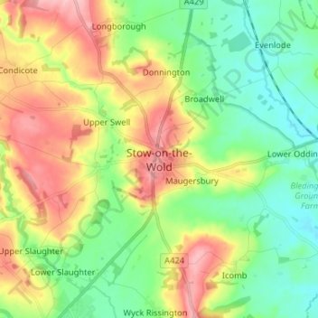
Nome: Mapa topográfico Stow-on-the-Wold, altitude, relevo.
Altitude média: 163 m
Altitude mínima: 110 m
Altitude máxima: 247 m
Faça uma doação
Outros mapas topográficos
Clique em um mapa para visualizar sua topografia, sua altitude e seu relevo.
Chedworth
United Kingdom > England > Gloucestershire > Cotswold District > Chedworth
Altitude média: 187 m
Worcestershire (detached)
United Kingdom > England > Gloucestershire > Cotswold District
Altitude média: 103 m
Faça uma doação
Cirencester Park
United Kingdom > England > Gloucestershire > Cotswold District > Sapperton
Altitude média: 162 m
Cold Aston
United Kingdom > England > Gloucestershire > Cotswold District > Cold Aston
Altitude média: 189 m
Cirencester
United Kingdom > England > Gloucestershire > Cotswold District
On Cotswold Avenue is the site of a Roman amphitheatre which, while buried, retains its shape in the earthen topography of the small park setting. Cirencester was one of the most substantial cities of Roman-era Britain.
Altitude média: 128 m
Faça uma doação
South Cerney
United Kingdom > England > Gloucestershire > Cotswold District > South Cerney
Altitude média: 93 m
Upper Rissington
United Kingdom > England > Gloucestershire > Cotswold District > Upper Rissington
Altitude média: 208 m
Faça uma doação
Bourton-on-the-Hill
United Kingdom > England > Gloucestershire > Cotswold District
Altitude média: 200 m
Little Rissington
United Kingdom > England > Gloucestershire > Cotswold District > Little Rissington
Altitude média: 171 m
Faça uma doação
Coberley
United Kingdom > England > Gloucestershire > Cotswold District > Coberley
Altitude média: 234 m
Bibury
United Kingdom > England > Gloucestershire > Cotswold District
The parish is approximately rectangular and stretches far to the rolling, elevated, north. It includes on outlying settlement, Ablington, in the upper valley. Bibury Farm is 300 metres (330 yd) from the village, 151 metres (495 ft) above Ordnance Datum (AOD), which is a similar elevation to much of the north.…
Altitude média: 135 m
Botany Bay Wood
United Kingdom > England > Gloucestershire > Cotswold District > Stow-on-the-Wold
Altitude média: 171 m
Faça uma doação
Baunton
United Kingdom > England > Gloucestershire > Cotswold District > Baunton
Altitude média: 146 m
Faça uma doação
Somerford Keynes
United Kingdom > England > Gloucestershire > Cotswold District > Somerford Keynes
Altitude média: 92 m
Evenlode
United Kingdom > England > Gloucestershire > Cotswold District > Evenlode
Altitude média: 134 m
Great Rissington
United Kingdom > England > Gloucestershire > Cotswold District > Great Rissington
Altitude média: 168 m
Long Newnton
United Kingdom > England > Gloucestershire > Cotswold District > Long Newnton
Altitude média: 117 m
Faça uma doação
Bagendon
United Kingdom > England > Gloucestershire > Cotswold District > Bagendon
Altitude média: 171 m
Didmarton
United Kingdom > England > Gloucestershire > Cotswold District > Didmarton
Altitude média: 147 m
Faça uma doação
Daglingworth
United Kingdom > England > Gloucestershire > Cotswold District > Daglingworth
Altitude média: 169 m
Faça uma doação
Poulton
United Kingdom > England > Gloucestershire > Cotswold District > Poulton
Altitude média: 109 m
Bourton-on-the-Water
United Kingdom > England > Gloucestershire > Cotswold District
Altitude média: 155 m
Faça uma doação
Windrush
United Kingdom > England > Gloucestershire > Cotswold District > Windrush
Altitude média: 155 m
Faça uma doação
Sherborne
United Kingdom > England > Gloucestershire > Cotswold District > Sherborne
Altitude média: 156 m
Elkstone
United Kingdom > England > Gloucestershire > Cotswold District > Elkstone
Altitude média: 234 m
Down Ampney
United Kingdom > England > Gloucestershire > Cotswold District > Down Ampney
Altitude média: 85 m
Faça uma doação
Hazleton
United Kingdom > England > Gloucestershire > Cotswold District > Hazleton
Altitude média: 227 m
Faça uma doação
Fairford
United Kingdom > England > Gloucestershire > Cotswold District > Fairford
Altitude média: 98 m
Faça uma doação
Bushley Muzzard, Brimpsfield
United Kingdom > England > Gloucestershire > Cotswold District > Nettleton > Watercombe
Altitude média: 261 m
Knap House Quarry, Birdlip
United Kingdom > England > Gloucestershire > Cotswold District > Birdlip
Altitude média: 222 m
Faça uma doação
Cirencester
United Kingdom > England > Gloucestershire > Cotswold District
On Cotswold Avenue is the site of a Roman amphitheatre which, while buried, retains its shape in the earthen topography of the small park setting. Cirencester was one of the most substantial cities of Roman-era Britain.
Altitude média: 128 m
Faça uma doação
Didmarton
United Kingdom > England > Gloucestershire > Cotswold District > Didmarton
Altitude média: 147 m
Faça uma doação
Cirencester
United Kingdom > England > Gloucestershire > Cotswold District > Chesterton
On Cotswold Avenue is the site of a Roman amphitheatre which, while buried, retains its shape in the earthen topography of the small park setting. Cirencester was one of the most substantial cities of Roman-era Britain.
Altitude média: 128 m
Faça uma doação
Cirencester
United Kingdom > England > Gloucestershire > Cotswold District > Chesterton
On Cotswold Avenue is the site of a Roman amphitheatre which, while buried, retains its shape in the earthen topography of the small park setting. Cirencester was one of the most substantial cities of Roman-era Britain.
Altitude média: 128 m