
Obrigado por apoiar este site ❤️
Faça uma doação
Faça uma doação
Mapa topográfico Annecy
Clique no mapa para exibir a altitude.
Obrigado por apoiar este site ❤️
Faça uma doação
Faça uma doação
Annecy
Annecy has an oceanic climate (Köppen Cfb) in spite of its relatively far inland position. Influenced by its elevation, summers are rather moderate on average, although they can be highly variable with extreme heat spikes. Winters see occasional freezing temperatures, but most often stays in the single-digits during daytime with frequent cold rain. Air frosts are normal during the night and snowfall is not uncommon. Overall, winters are colder than in Chambéry.
Obrigado por apoiar este site ❤️
Faça uma doação
Faça uma doação
Sobre este mapa
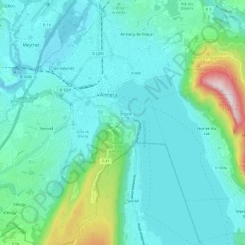
Nome: Mapa topográfico Annecy, altitude, relevo.
Altitude média: 554 m
Altitude mínima: 409 m
Altitude máxima: 1.275 m
Obrigado por apoiar este site ❤️
Faça uma doação
Faça uma doação