
Obrigado por apoiar este site ❤️
Faça uma doação
Faça uma doação
Mapa topográfico Blue Mountain Park
Clique no mapa para exibir a altitude.
Obrigado por apoiar este site ❤️
Faça uma doação
Faça uma doação
Sobre este mapa
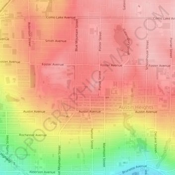
Nome: Mapa topográfico Blue Mountain Park, altitude, relevo.
Altitude média: 119 m
Altitude mínima: 9 m
Altitude máxima: 169 m
Obrigado por apoiar este site ❤️
Faça uma doação
Faça uma doação
Outros mapas topográficos
Clique em um mapa para visualizar sua topografia, sua altitude e seu relevo.
Crystal Falls
Canada > British Columbia > Metro Vancouver Regional District > Coquitlam
Altitude média: 221 m
Coquitlam
Canada > British Columbia > Metro Vancouver Regional District > Coquitlam
Southwest Coquitlam comprises the original core of the city, with Maillardville and Fraser River industrial sector giving way to the large residential areas of Austin Heights, colloquially referred to as "The Bump" due to its high and flat plateau topography. These older residences, with larger property…
Altitude média: 230 m