
Faça uma doação
Mapa topográfico Kerrville
Clique no mapa para exibir a altitude.
Faça uma doação
Kerrville
Kerrville is characterized by a diverse and rugged topography. Nestled along the Guadalupe River, it sits at an elevation averaging 1,600 feet above sea level, with varying terrain that includes gentle hills, steep slopes, and flat river valleys. This area features numerous limestone hills, characteristic of the Edwards Plateau, as well as smaller ridges and escarpments that create an intricate landscape. The terrain includes densely vegetated areas along the river and open fields across the rolling hills, providing distinct natural beauty and varied ecosystems. This rugged yet scenic region is marked by changes in elevation that add to its appeal for outdoor recreation, such as hiking and scenic drives, especially around the Guadalupe River and nearby creeks.
Faça uma doação
Sobre este mapa
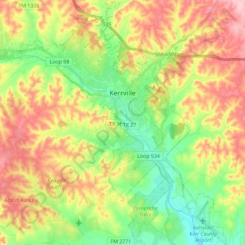
Nome: Mapa topográfico Kerrville, altitude, relevo.
Local: Kerrville, Kerr County, Texas, United States (29.96182 -99.21161 30.10132 -99.07165)
Altitude média: 545 m
Altitude mínima: 464 m
Altitude máxima: 646 m
Faça uma doação
Outros mapas topográficos
Clique em um mapa para visualizar sua topografia, sua altitude e seu relevo.