
Mapa topográfico Mühlhausen
Mapa interativo
Clique no mapa para exibir a altitude.
Sobre este mapa
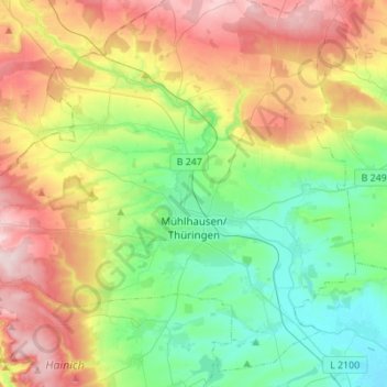
Nome: Mapa topográfico Mühlhausen, altitude, relevo.
Local: Mühlhausen, Unstrut-Hainich-Kreis, Thuringia, Germany (51.14553 10.36172 51.30347 10.57395)
Altitude média: 288 m
Altitude mínima: 175 m
Altitude máxima: 486 m
Mühlhausen is situated in the flat landscape of the Thuringian Basin, a very fertile area covering the northern centre of Thuringia at an elevation of approximately 215 metres above sea level. To the north and west, the terrain gets hilly, whereas to the south and east lie wide agricultural areas, much like most of the municipal territory itself. Furthermore, there are two forests within the territory: the Stadtwald (as part of the Hainich) in the west and the Mühlhäuser Hardt between the Windeberg district and Menteroda. Both are broadleaf forests with beeches prevalent. The Hainich hills south-west of Mühlhausen became Thuringia's only National Park in 1997 because of their old near-natural beech forests. The highest hills within the Mühlhausen terrain reach approximately 400 metres of elevation. The main river crossing the city in northwest–southeast direction is the Unstrut. Furthermore, there are many small tributaries running from the western hills through Mühlhausen to the Unstrut like the Schwemmnotte, which is dividing the inner city.
Outros mapas topográficos
Clique em um mapa para visualizar sua topografia, sua altitude e seu relevo.
Höngeda
Germany > Thuringia > Unstrut-Hainich-Kreis > Mühlhausen
Höngeda, Mühlhausen, Unstrut-Hainich-Kreis, Thuringia, 99998, Germany
Altitude média: 202 m
Unstrut-Hainich
Germany > Thuringia > Unstrut-Hainich-Kreis > Unstrut-Hainich
Unstrut-Hainich, Unstrut-Hainich-Kreis, Thuringia, 99991, Germany
Altitude média: 279 m
Rodeberg
Germany > Thuringia > Unstrut-Hainich-Kreis > Rodeberg
Rodeberg, Südeichsfeld, Unstrut-Hainich-Kreis, Thuringia, Germany
Altitude média: 422 m
Thamsbrück
Germany > Thuringia > Unstrut-Hainich-Kreis > Bad Langensalza > Thamsbrück
Thamsbrück, Bad Langensalza, Unstrut-Hainich-Kreis, Thuringia, 99947, Germany
Altitude média: 189 m