
Mapa topográfico Bullet
Mapa interativo
Clique no mapa para exibir a altitude.
Sobre este mapa
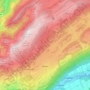
Nome: Mapa topográfico Bullet, altitude, relevo.
Local: Bullet, District du Jura-Nord vaudois, Vaud, Switzerland (46.81655 6.52223 46.87143 6.59386)
Altitude média: 1.173 m
Altitude mínima: 514 m
Altitude máxima: 1.590 m
The municipality is located in the Vaudois Jura. The town lies on the end moraine of the ice age era Rhone glacier. It consists of the village of Bullet (elevation 1,143 m (3,750 ft)) and the hamlets of Les Rasses, Les Cluds, La Crochère, Les Crosats and La Frétaz.