
Faça uma doação
Mapa topográfico Manizales
Clique no mapa para exibir a altitude.
Faça uma doação
Manizales
Manizales is the capital city of one of the smallest Colombian departments. The city is described as having an "abrupt topography", and lies on the Colombian Central Mountain Range (part of the longest continental mountain range, the Andes), with a great deal of ridgelines and steep slopes, which, combined with the seismic instability of the area, has required architectural adaptations and public works to make the city safer. Even though Manizales has this very difficult topography, there are many coffee plantations in its fertile lands. The city is located in the northern part of the Colombian Coffee-Growers Axis ("Eje Cafetero"), near the volcano Nevado del Ruiz, which has an altitude of 5,321 meters (17,457.3 ft).
Faça uma doação
Sobre este mapa
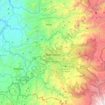
Nome: Mapa topográfico Manizales, altitude, relevo.
Altitude média: 2.114 m
Altitude mínima: 774 m
Altitude máxima: 4.844 m
Faça uma doação
Outros mapas topográficos
Clique em um mapa para visualizar sua topografia, sua altitude e seu relevo.
Manizales
Manizales is the capital city of one of the smallest Colombian departments. The city is described as having an "abrupt topography", and lies on the Colombian Central Mountain Range (part of the longest continental mountain range, the Andes), with a great deal of ridgelines and steep slopes, which, combined…
Altitude média: 2.010 m
Faça uma doação