
Mapa topográfico León
Mapa interativo
Clique no mapa para exibir a altitude.
Sobre este mapa
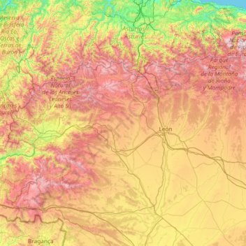
Nome: Mapa topográfico León, altitude, relevo.
Local: León, Castile and León, Spain (42.02928 -7.07707 43.23820 -4.73236)
Altitude média: 913 m
Altitude mínima: 0 m
Altitude máxima: 2.527 m
As for the temperatures, in general it is a cold climate due to the altitude and the abundance of frost (which persist from November to May), being more intense in the mountainous areas reaching -18 °C. Vega de Liordes, an enclave in the León sector of Picos de Europa belonging to the municipality of Posada de Valdeón registered −35.8 °C (−32.4 °F) on January 7, 2021.
Outros mapas topográficos
Clique em um mapa para visualizar sua topografia, sua altitude e seu relevo.
Cortiguera
Spain > Castile and León > El Bierzo
Cortiguera, Cabañas Raras, El Bierzo, León, Castile and León, 24412, Spain
Altitude média: 552 m
Pico Mazo
Spain > Castile and León > Valle de Sedano
Pico Mazo, Valle de Sedano, Burgos, Castile and León, Spain
Altitude média: 802 m
Montealegre de Campos
Spain > Castile and León > Montealegre de Campos
Montealegre de Campos, Valladolid, Castile and León, 47816, Spain
Altitude média: 811 m
Villanubla
Spain > Castile and León > Villanubla
Villanubla, Valladolid, Castile and León, 47620, Spain
Altitude média: 836 m
Valdejimena
Spain > Castile and León > Frechilla
Valdejimena, Frechilla, Palencia, Castile and León, Spain
Altitude média: 786 m
Melgar de Fernamental
Spain > Castile and León > Melgar de Fernamental
Melgar de Fernamental, Odra-Pisuerga, Burgos, Castile and León, Spain
Altitude média: 826 m
La Maya
Spain > Castile and León > La Maya
La Maya, Tierra de Alba, Salamanca, Castile and León, Spain
Altitude média: 850 m
Maraña
Spain > Castile and León > Maraña
Maraña, León, Castile and León, 24996, Spain
Altitude média: 1.465 m
Pico Almanzor
Spain > Castile and León > Candeleda
Pico Almanzor, Candeleda, Comarca de Arenas de San Pedro, Ávila, Castile and León, Spain
Altitude média: 2.159 m