
Mapa topográfico Yantai City
Mapa interativo
Clique no mapa para exibir a altitude.
Sobre este mapa
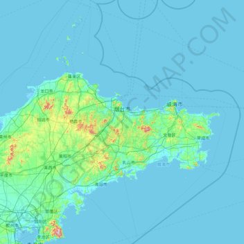
Nome: Mapa topográfico Yantai City, altitude, relevo.
Local: Yantai City, Shandong, 264000, China (36.45070 119.54756 38.42078 121.92903)
Altitude média: 39 m
Altitude mínima: -2 m
Altitude máxima: 877 m
Yantai is located along the north coast of the Shandong Peninsula, south of the junction of Bohai Sea and Yellow Sea and parallel to the southern coast of Liaoning. The topographical breakdown consists of: