
Faça uma doação
Mapa topográfico Cabatuan
Clique no mapa para exibir a altitude.
Faça uma doação
Sobre este mapa
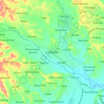
Nome: Mapa topográfico Cabatuan, altitude, relevo.
Local: Cabatuan, Iloilo, Western Visayas, 5031, Philippines (10.83986 122.44195 10.91986 122.52195)
Altitude média: 74 m
Altitude mínima: 32 m
Altitude máxima: 167 m
Faça uma doação
Outros mapas topográficos
Clique em um mapa para visualizar sua topografia, sua altitude e seu relevo.
Faça uma doação
Faça uma doação
Panay
Panay island is the sixth largest island in the Philippines by area, with a total land area of 12,011 km2 (4,637 sq mi). Mount Madja-as is the highest point in Panay with an elevation of 2,117 metres (6,946 ft) above sea level, located in town of Culasi in the northern province of Antique. Central Panay…
Altitude média: 117 m
Guimbal
Guimbal, a coastal municipality, is located at the south-western part of Iloilo province. It is situated between the coordinates of 1250 57’ longitude, and 100 39’ latitude. It is 29 kilometres (18 mi) from Iloilo City, and has a total land area of 4,461 hectares (11,020 acres). It is only six feet above…
Altitude média: 27 m
Faça uma doação
Faça uma doação
Faça uma doação
Faça uma doação
Faça uma doação
Panay
Panay island is the sixth largest island in the Philippines by area, with a total land area of 12,011 km2 (4,637 sq mi). Mount Madja-as is the highest point in Panay with an elevation of 2,117 metres (6,946 ft) above sea level, located in town of Culasi in the northern province of Antique. Central Panay…
Altitude média: 117 m
Faça uma doação
Guimbal
Guimbal, a coastal municipality, is located at the south-western part of Iloilo province. It is situated between the coordinates of 1250 57’ longitude, and 100 39’ latitude. It is 29 kilometres (18 mi) from Iloilo City, and has a total land area of 4,461 hectares (11,020 acres). It is only six feet above…
Altitude média: 27 m
Faça uma doação
Faça uma doação
Guimbal
Guimbal, a coastal municipality, is located at the south-western part of Iloilo province. It is situated between the coordinates of 1250 57’ longitude, and 100 39’ latitude. It is 29 kilometres (18 mi) from Iloilo City, and has a total land area of 4,461 hectares (11,020 acres). It is only six feet above…
Altitude média: 27 m
Panay
Panay island is the sixth largest island in the Philippines by area, with a total land area of 12,011 km2 (4,637 sq mi). Mount Madja-as is the highest point in Panay with an elevation of 2,117 metres (6,946 ft) above sea level, located in town of Culasi in the northern province of Antique. Central Panay…
Altitude média: 117 m
Faça uma doação
Guimbal
Guimbal, a coastal municipality, is located at the south-western part of Iloilo province. It is situated between the coordinates of 1250 57’ longitude, and 100 39’ latitude. It is 29 kilometres (18 mi) from Iloilo City, and has a total land area of 4,461 hectares (11,020 acres). It is only six feet above…
Altitude média: 27 m
Faça uma doação
Panay
Panay island is the sixth largest island in the Philippines by area, with a total land area of 12,011 km2 (4,637 sq mi). Mount Madja-as is the highest point in Panay with an elevation of 2,117 metres (6,946 ft) above sea level, located in town of Culasi in the northern province of Antique. Central Panay…
Altitude média: 117 m
Faça uma doação