
Mapa topográfico Rikers Island
Mapa interativo
Clique no mapa para exibir a altitude.
Sobre este mapa
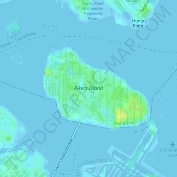
Nome: Mapa topográfico Rikers Island, altitude, relevo.
Local: Rikers Island, Bronx County, New York City, New York, USA (40.78537 -73.89269 40.79838 -73.87089)
Altitude média: 2 m
Altitude mínima: -12 m
Altitude máxima: 18 m
Outros mapas topográficos
Clique em um mapa para visualizar sua topografia, sua altitude e seu relevo.
Harlem
USA > New York > New York City
Harlem, Manhattan, Manhattan Community Board 10, New York County, New York City, New York, USA
Altitude média: 16 m
Chinatown
USA > New York > New York City
Chinatown, Manhattan, Manhattan Community Board 2, New York County, New York City, New York, USA
Altitude média: 12 m
Governors Island
USA > New York > New York City
Governors Island, Manhattan Community Board 1, New York County, New York City, New York, USA
Altitude média: 1 m