
Mapa topográfico Stradbally
Mapa interativo
Clique no mapa para exibir a altitude.
Sobre este mapa
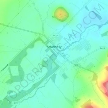
Nome: Mapa topográfico Stradbally, altitude, relevo.
Altitude média: 92 m
Altitude mínima: 69 m
Altitude máxima: 167 m
Outros mapas topográficos
Clique em um mapa para visualizar sua topografia, sua altitude e seu relevo.
Mountmellick
Mountmellick, The Municipal District of Borris-in-Ossory — Mountmellick, County Laois, Leinster, Ireland
Altitude média: 76 m
Burke's Cross
Burke's Cross, Lacka ED, The Municipal District of Borris-in-Ossory — Mountmellick, County Laois, Leinster, Ireland
Altitude média: 195 m
Trumra Rock
Trumra Rock, Trumra ED, The Municipal District of Borris-in-Ossory — Mountmellick, County Laois, Leinster, Ireland
Altitude média: 105 m
Timahoe
Timahoe, The Municipal District of Graiguecullen — Portarlington, County Laois, Leinster, R32 Y09T, Ireland
Altitude média: 146 m
The Municipal District of Portlaoise
The Municipal District of Portlaoise, County Laois, Leinster, Ireland
Altitude média: 138 m
The Municipal District of Graiguecullen — Portarlington
The Municipal District of Graiguecullen — Portarlington, County Laois, Leinster, Ireland
Altitude média: 113 m
Killadooley
Killadooley, Ballybrophy ED, The Municipal District of Borris-in-Ossory — Mountmellick, County Laois, Leinster, Ireland
Altitude média: 122 m