
Obrigado por apoiar este site ❤️
Faça uma doação
Faça uma doação
Mapa topográfico Red Hill
Clique no mapa para exibir a altitude.
Obrigado por apoiar este site ❤️
Faça uma doação
Faça uma doação
Sobre este mapa
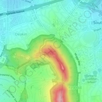
Nome: Mapa topográfico Red Hill, altitude, relevo.
Altitude média: 622 m
Altitude mínima: 574 m
Altitude máxima: 746 m
Obrigado por apoiar este site ❤️
Faça uma doação
Faça uma doação
Outros mapas topográficos
Clique em um mapa para visualizar sua topografia, sua altitude e seu relevo.
Lake Burley Griffin
Charles Robert Scrivener (1855–1923) recommended the site for Canberra in 1909, which was to be a planned capital city for the country. One of the reasons for the location's selection was its ability to store water "for ornamental purposes at reasonable cost"; Scrivener's work had demonstrated that the…
Altitude média: 589 m
Obrigado por apoiar este site ❤️
Faça uma doação
Faça uma doação
Obrigado por apoiar este site ❤️
Faça uma doação
Faça uma doação