
Mapa topográfico Les Hayons
Mapa interativo
Clique no mapa para exibir a altitude.
Sobre este mapa
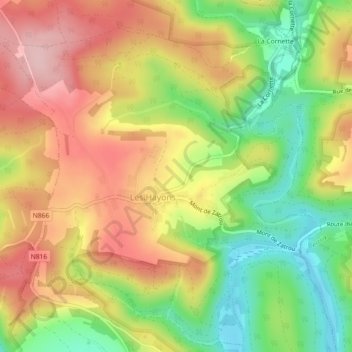
Nome: Mapa topográfico Les Hayons, altitude, relevo.
Altitude média: 331 m
Altitude mínima: 231 m
Altitude máxima: 424 m
Outros mapas topográficos
Clique em um mapa para visualizar sua topografia, sua altitude e seu relevo.
Corbion
Belgique > Luxembourg > Bouillon > Corbion
Corbion, Bouillon, Neufchâteau, Luxembourg, Wallonie, 6838, Belgique
Altitude média: 337 m
Noirefontaine
Belgique > Luxembourg > Bouillon > Noirefontaine
Noirefontaine, Bouillon, Neufchâteau, Luxembourg, Wallonie, 6831, Belgique
Altitude média: 360 m
Menuchenet
Belgique > Luxembourg > Bouillon > Mogimont
Menuchenet, Mogimont, Bouillon, Neufchâteau, Luxembourg, Wallonie, 6832, Belgique
Altitude média: 405 m
Route d'Alle
Belgique > Luxembourg > Bouillon > Rochehaut > Frahan
Route d'Alle, Frahan, Rochehaut, Bouillon, Neufchâteau, Luxembourg, Wallonie, 6838, Belgique
Altitude média: 304 m