
Mapa topográfico Slaithwaite
Clique no mapa para exibir a altitude.
Slaithwaite
In the 1848 edition of 'A Topographical Dictionary of England', Samuel Lewis (the editor) wrote:- "the lands are in meadow and pasture, with a small portion of arable; the scenery is bold and romantic. In the quarries of the district are found vegetable fossils, especially firs and other mountain trees. The village is beautifully seated in the valley of the river Colne; the inhabitants are chiefly employed in the woollen manufacture, in the spinning of cotton and silk, and in silk-weaving"
Sobre este mapa
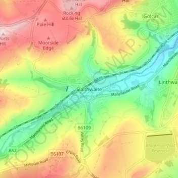
Nome: Mapa topográfico Slaithwaite, altitude, relevo.
Altitude média: 241 m
Altitude mínima: 107 m
Altitude máxima: 391 m
Outros mapas topográficos
Clique em um mapa para visualizar sua topografia, sua altitude e seu relevo.