
Mapa topográfico Vagamon
Mapa interativo
Clique no mapa para exibir a altitude.
Sobre este mapa
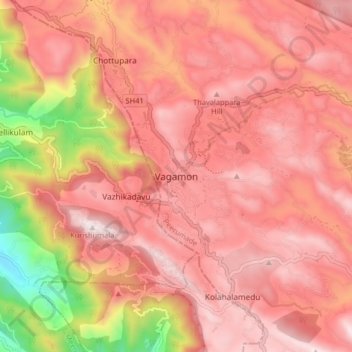
Nome: Mapa topográfico Vagamon, altitude, relevo.
Local: Vagamon, Peerumade, Idukki District, Kerala, 685503, India (9.64860 76.86686 9.72860 76.94686)
Altitude média: 866 m
Altitude mínima: 179 m
Altitude máxima: 1.190 m
Vagamon, due to its elevation and climate, has a unique ecosystem, leading to the emergence of rich natural vegetation, plant species, shola forests etc. From the early 20th century plantation crops like tea, coffee started. Vagamon hills are home to less explored flora and fauna. A faunal diversity study conducted by Dr Pratheesh Mathew recorded 112 species of moths from 16 families under eight superfamilies and has become the prominent faunal diversity study in this area. The author has also recorded sightings of many species of insects, annelids, amphibians, lizards, snakes, birds and mammals. A wide variety of flowering and non-flowering plants, including rare Cycas species, has also been noted. The ongoing faunal and floral surveys are expected to shed light on the richness of biodiversity at this location. The flourishing tourism and related developments are predicted to have a negative impact on the flora and fauna of this region.
Outros mapas topográficos
Clique em um mapa para visualizar sua topografia, sua altitude e seu relevo.
Chuzhuppu
India > Kerala > Peerumade > Peruvanthanam
Chuzhuppu, Peruvanthanam, Peerumade, Idukki District, Kerala, 685532, India
Altitude média: 308 m
Kuvalettam
Kuvalettam, Peerumade, Idukki District, Kerala, 685503, India
Altitude média: 979 m
Kattadikavala
India > Kerala > Peerumade > Cheenthalar
Kattadikavala, Cheenthalar, Peerumade, Idukki District, Kerala, 685501, India
Altitude média: 864 m
Old Pambanar
India > Kerala > Peerumade > Pambanar
Old Pambanar, Pambanar, Peerumade, Idukki District, Kerala, 685537, India
Altitude média: 1.072 m
Vandiperiyar
Vandiperiyar, Peerumade, Idukki District, Kerala, 685533, India
Altitude média: 919 m