
Mapa topográfico Dobel
Mapa interativo
Clique no mapa para exibir a altitude.
Dobel
The municipality (Gemeinde) of Dobel is located situated in the district of Calw, in the German state of Baden-Württemberg. Dobel lies at the northwest corner of the district, bordering the districts of Rastatt and the Enz. The municipal area is physically located in the Grinde area of the Black Forest, on a plateau between the valleys of the Enz and Alb rivers. Elevation above sea level in the municipal area ranges from a high of 882 meters (2,894 ft) Normalnull (NN) at the top of the Rosskopf to a low of 405 meters (1,329 ft) NN.
Sobre este mapa
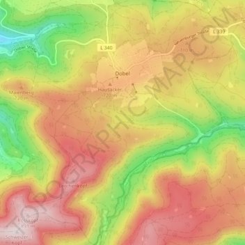
Nome: Mapa topográfico Dobel, altitude, relevo.
Altitude média: 658 m
Altitude mínima: 366 m
Altitude máxima: 901 m
Outros mapas topográficos
Clique em um mapa para visualizar sua topografia, sua altitude e seu relevo.
Bad Teinach
Germany > Baden-Württemberg > Landkreis Calw
The township (Stadt) of Bad Teinach-Zavelstein is located at the center of the district of Calw, in Baden-Württemberg, one of the 16 States of the Federal Republic of Germany. Bad Teinach-Zavelstein's municipal area rests upon the plateau of the Enz and Nagold rivers, a landscape defined by severe river…
Altitude média: 557 m
Zieflensberg
Germany > Baden-Württemberg > Landkreis Calw > Bad Herrenalb > Zieflensberg
Altitude média: 668 m