
Faça uma doação
Mapa topográfico Parque Nacional Cajas
Clique no mapa para exibir a altitude.
Faça uma doação
Parque Nacional Cajas
The highest point is the 4,450 m high Cerro Arquitectos (Architects Hill), and the elevation of roads reaches higher than 4,310 meters (13,550 feet). About 270 lakes and lagoons are present in the páramo of Cajas. Luspa is the largest of these lake and extends over 78 hectares with a maximum depth of 68 m at a perimeter of 5,161 m. Like the other lakes it is of glacial origin, and glaciation shaped the landscape of Cajas leaving U-shaped valleys and ravines. Cajas provides about 60% of the drinking water for the Cuenca area. Two of the four rivers of Cuenca originate from Cajas, the Tomebamba and Yanuncay rivers which eventually drain into the Amazon River. The Paute river also links to the Amazon. As the park straddles the continental divide, its western drainage, the Balao and Cañar link to the Pacific ocean. The modern road crosses the continental divide at the pass "Tres Cruces" (4,255 m). This section is the most western part of the continental divide of South America.
Faça uma doação
Sobre este mapa
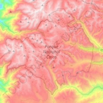
Nome: Mapa topográfico Parque Nacional Cajas, altitude, relevo.
Local: Parque Nacional Cajas, Cuenca, Azuay, Ecuador (-2.95090 -79.38609 -2.74574 -79.14122)
Altitude média: 3.767 m
Altitude mínima: 2.285 m
Altitude máxima: 4.514 m
Faça uma doação
Outros mapas topográficos
Clique em um mapa para visualizar sua topografia, sua altitude e seu relevo.
Cuenca
Cuenca, officially Santa Ana de los Ríos de Cuenca, is an Ecuadorian city, head of the canton of the same name and capital of the province of Azuay, as well as its largest and most populated city. It is crossed by the Tomebamba, Tarqui, Yanuncay and Machángara rivers, in the south-central inter-Andean region…
Altitude média: 2.973 m
Faça uma doação