
Mapa topográfico Bodenhof
Mapa interativo
Clique no mapa para exibir a altitude.
Sobre este mapa
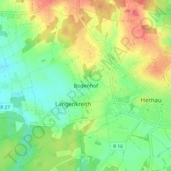
Nome: Mapa topográfico Bodenhof, altitude, relevo.
Altitude média: 511 m
Altitude mínima: 483 m
Altitude máxima: 552 m
Outros mapas topográficos
Clique em um mapa para visualizar sua topografia, sua altitude e seu relevo.
Kollersried
Deutschland > Bayern > Landkreis Regensburg > Hemau > Laufenthal > Kollersried
Kollersried, Laufenthal, Hemau, Landkreis Regensburg, Bayern, 93155, Deutschland
Altitude média: 501 m