
Mapa topográfico Oxnard
Clique no mapa para exibir a altitude.
Sobre este mapa
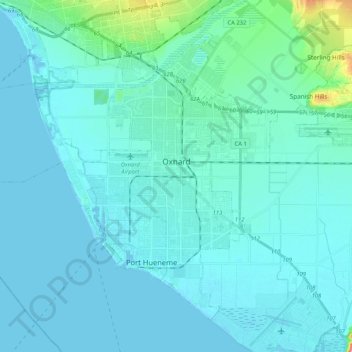
Nome: Mapa topográfico Oxnard, altitude, relevo.
Local: Oxnard, Ventura County, California, United States (34.11932 -119.32922 34.26147 -119.11970)
Altitude média: 16 m
Altitude mínima: -1 m
Altitude máxima: 179 m
Outros mapas topográficos
Clique em um mapa para visualizar sua topografia, sua altitude e seu relevo.
Mount Pinos
United States > California > Ventura County
During and immediately after heavy snow storms it may not be possible to drive to the top of Mount Pinos Road due to the lack of snow plow availability. In such cases it is common for the Kern County Roads Department to close a snow gate lower on the mountain. It is still possible to ski from the snow gate and…
Altitude média: 2.468 m
Lake Piru
United States > California > Ventura County
The elevation of the reservoir is 1,043 ft (318 m), and the elevation of the dam spillway is 1,055 ft (322 m). The dam is owned and operated by the United Water Conservation District based in nearby Santa Paula, California. The district is a multi-service district providing flood control, recreation services,…
Altitude média: 375 m
Newbury Park
United States > California > Ventura County > Thousand Oaks > Newbury Park
Newbury Park can be described as a town, community, or section mostly within the Thousand Oaks city limits in addition to rural areas west of Thousand Oaks. Newbury Park is bordered by Lynn Road in the east and the Conejo Grade on the west. It borders the Santa Monica Mountains in the south, while Hill Canyon…
Altitude média: 262 m
Greenwich Village
United States > California > Ventura County > Thousand Oaks > Greenwich Village
Altitude média: 275 m
Casitas Springs
United States > California > Ventura County > Ventura > Casitas Springs
Altitude média: 182 m