
Mapa topográfico Western Park
Mapa interativo
Clique no mapa para exibir a altitude.
Sobre este mapa
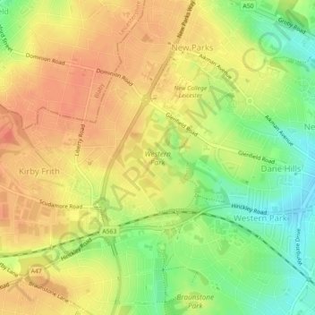
Nome: Mapa topográfico Western Park, altitude, relevo.
Altitude média: 88 m
Altitude mínima: 61 m
Altitude máxima: 105 m
Outros mapas topográficos
Clique em um mapa para visualizar sua topografia, sua altitude e seu relevo.
Grand Union Canal
United Kingdom > England > Leicester
Grand Union Canal, Leicester, City of Leicester, East Midlands, England, LE3 5EP, United Kingdom
Altitude média: 65 m
Castle Hill Country Park
United Kingdom > England > Leicester
Castle Hill Country Park, Bradgate Heights, Leicester, City of Leicester, East Midlands, England, United Kingdom
Altitude média: 81 m
Spinney Hill Park
United Kingdom > England > Leicester
Spinney Hill Park, Spinney Hills, Leicester, City of Leicester, East Midlands, England, LE5 5DN, United Kingdom
Altitude média: 73 m