
Mapa topográfico Röfleuten
Mapa interativo
Clique no mapa para exibir a altitude.
Sobre este mapa
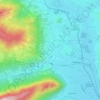
Nome: Mapa topográfico Röfleuten, altitude, relevo.
Altitude média: 988 m
Altitude mínima: 843 m
Altitude máxima: 1.486 m
Outros mapas topográficos
Clique em um mapa para visualizar sua topografia, sua altitude e seu relevo.
Breitenberg
Deutschland > Bayern > Landkreis Ostallgäu > Pfronten
Breitenberg, Pfronten, Landkreis Ostallgäu, Bayern, 87459, Deutschland
Altitude média: 1.363 m
Ösch
Deutschland > Bayern > Landkreis Ostallgäu > Pfronten > Ösch
Ösch, Pfronten, Landkreis Ostallgäu, Bayern, 87459, Deutschland
Altitude média: 957 m
Weißbach
Deutschland > Bayern > Landkreis Ostallgäu > Pfronten
Weißbach, Pfronten, Landkreis Ostallgäu, Bayern, 87459, Deutschland
Altitude média: 909 m
Steinach
Deutschland > Bayern > Landkreis Ostallgäu > Pfronten > Steinach
Steinach, Pfronten, Landkreis Ostallgäu, Bayern, 87459, Deutschland
Altitude média: 986 m