
Mapa topográfico Knossington
Clique no mapa para exibir a altitude.
Sobre este mapa
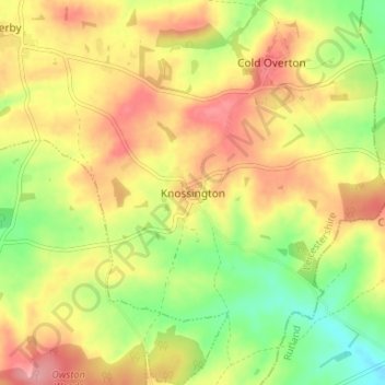
Nome: Mapa topográfico Knossington, altitude, relevo.
Altitude média: 172 m
Altitude mínima: 120 m
Altitude máxima: 218 m
Outros mapas topográficos
Clique em um mapa para visualizar sua topografia, sua altitude e seu relevo.
Bottesford
United Kingdom > England > Leicestershire > Melton
Bottesford's many listed buildings include the grade I listed 13th-century Church of St Mary the Virgin. There are two scheduled monuments within the village – Fleming's Bridge and the stone cross in the Market Place. The stocks and whipping post are Grade II listed. One of the Grade II listed buildings,…
Altitude média: 39 m
Croxton Kerrial
United Kingdom > England > Leicestershire > Melton > Croxton Kerrial
Altitude média: 128 m
Langham Brook
United Kingdom > England > Leicestershire > Melton > Saxby > Freeby
Altitude média: 94 m
Belvoir Castle
United Kingdom > England > Leicestershire > Melton > Belvoir
The traditional burial place of the Manners family was St Mary the Virgin's Church, Bottesford. Since elevation to the dukedom in 1703 most Dukes have been buried in the grounds of the mausoleum at Belvoir Castle. The mausoleum at Belvoir Castle was built by The 5th Duke of Rutland, following the death of his…
Altitude média: 82 m