
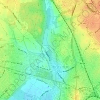
Mapa topográfico Countess of Chester Country Park
Mapa interativo
Clique no mapa para exibir a altitude.
Sobre este mapa
Nome: Mapa topográfico Countess of Chester Country Park, altitude, relevo.
Altitude média: 21 m
Altitude mínima: 4 m
Altitude máxima: 39 m
Outros mapas topográficos
Clique em um mapa para visualizar sua topografia, sua altitude e seu relevo.
Roman Fort
United Kingdom > England > Cheshire West and Chester > Chester
Roman Fort, Sandy Lane, Caldy Valley, Huntington, Chester, Cheshire West and Chester, North West England, England, CH3 6GS, United Kingdom
Altitude média: 21 m
Chester Castle
United Kingdom > England > Cheshire West and Chester > Chester
Chester Castle, City Walls, Chester Castle, Chester, Cheshire West and Chester, North West England, England, CH1 1SG, United Kingdom
Altitude média: 18 m
Poulton
United Kingdom > England > Cheshire West and Chester > Chester
Poulton, Poulton and Pulford, Chester, Cheshire West and Chester, England, CH4 9EE, United Kingdom
Altitude média: 14 m