
Faça uma doação
Mapa topográfico Cannock Chase
Clique no mapa para exibir a altitude.
Faça uma doação
Sobre este mapa
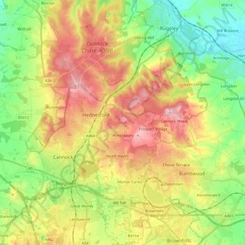
Nome: Mapa topográfico Cannock Chase, altitude, relevo.
Local: Cannock Chase, Staffordshire, England, United Kingdom (52.63964 -2.05464 52.77418 -1.91081)
Altitude média: 142 m
Altitude mínima: 61 m
Altitude máxima: 243 m
Faça uma doação
Outros mapas topográficos
Clique em um mapa para visualizar sua topografia, sua altitude e seu relevo.
Burton-on-Trent
United Kingdom > England > Staffordshire > East Staffordshire
Burton is about 109 miles (175 km) north west of London, about 30 miles north east of Birmingham, the UK's second largest city and about 23 miles east of the county town Stafford. It is at the easternmost border of the county of Staffordshire with Derbyshire, its suburbs and the course of the River Trent…
Altitude média: 69 m
Swan Bank
United Kingdom > England > Staffordshire > Newcastle-under-Lyme > Madeley Heath
Altitude média: 135 m
Faça uma doação
The Moss
United Kingdom > England > Staffordshire > Newcastle-under-Lyme > Madeley > The Moss
Altitude média: 122 m