
Faça uma doação
Mapa topográfico Bīrbhūm
Clique no mapa para exibir a altitude.
Faça uma doação
Sobre este mapa
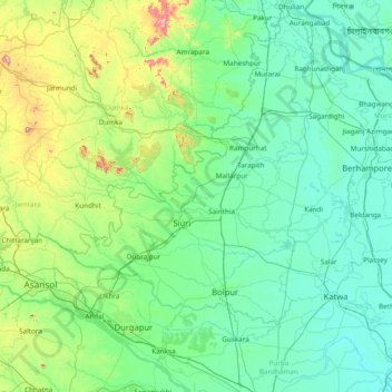
Nome: Mapa topográfico Bīrbhūm, altitude, relevo.
Local: Bīrbhūm, Birbhum, West Bengal, 731132, India (23.30000 86.88333 24.70000 88.28333)
Altitude média: 86 m
Altitude mínima: 4 m
Altitude máxima: 652 m
Faça uma doação
Outros mapas topográficos
Clique em um mapa para visualizar sua topografia, sua altitude e seu relevo.
Faça uma doação
Purulia
Several rivers flow across Purulia district. Among these Kangsabati, Kumari, Silabati (silai), Dwarakeswar, Subarnarekha and Damodar are the important ones. Although several rivers flows across the district, 50% of the water run off due to the undulated topography. There are also several Small dams like…
Altitude média: 225 m
Purba Medinipur District
Purba Medinipur district is part of the lower Indo-Gangetic Plain and Eastern coastal plains. Topographically, the district can be divided into two parts – (a) almost entirely flat plains on the west, east and north, (b) the coastal plains on the south. The vast expanse of land is formed of alluvium and is…
Altitude média: 6 m
Bankura - II
Bankura II CD block is located in the central part of the district. It belongs to the Bankura-Bishnupur Rarh Plains. The elevation rises gradually in the undulating surface area but in the hilly tract it rises abruptly.
Altitude média: 101 m
Faça uma doação
Mandirbazar
Mandirbazar CD block is located at 22°09′48″N 88°19′33″E / 22.1633°N 88.3258°E / 22.1633; 88.3258. It has an average elevation of 7 metres (23 ft).
Altitude média: 4 m
Faça uma doação
Bardhaman
India > West Bengal > Burdwan - I
The region has an average elevation of 40 metres (131 ft). The city is situated 1100 km from New Delhi and a little less than 100 km north-west of Kolkata on the Grand Trunk Road (National Highway 19) and Eastern Railway. The chief rivers are the Damodar and the Banka.
Altitude média: 31 m
Faça uma doação
Faça uma doação
Cooch Behar
Cooch Behar is a flat region with a slight southeastern slope along which the main rivers of the district flow. Most of the highland areas are in the Sitalkuchi region, and most of the low-lying lands lie in Dinhata region. The elevation of the town is 48 meters above mean sea level. The Torsa river flows by…
Altitude média: 41 m
Faça uma doação