
Faça uma doação
Mapa topográfico Wedmore
Clique no mapa para exibir a altitude.
Faça uma doação
Sobre este mapa
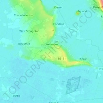
Nome: Mapa topográfico Wedmore, altitude, relevo.
Local: Wedmore, Somerset, England, United Kingdom (51.17976 -2.87810 51.25944 -2.74537)
Altitude média: 15 m
Altitude mínima: 0 m
Altitude máxima: 148 m
Faça uma doação
Outros mapas topográficos
Clique em um mapa para visualizar sua topografia, sua altitude e seu relevo.
Chard
United Kingdom > England > Somerset
Chard is a town and a civil parish in the English county of Somerset. It lies on the A30 road near the Devon and Dorset borders, 15 miles (24 km) south west of Yeovil. The parish has a population of approximately 14,000 and, at an elevation of 121 metres (397 ft), Chard is the southernmost and one of the…
Altitude média: 135 m
Faça uma doação
Faça uma doação
Halse Combe
United Kingdom > England > Somerset > Somerset West and Taunton > Allerford > Horner
Altitude média: 134 m
Allerford
United Kingdom > England > Somerset > Somerset West and Taunton > Allerford
Altitude média: 112 m
Horner Water
United Kingdom > England > Somerset > Somerset West and Taunton > Luccombe
Altitude média: 248 m
Faça uma doação
Bossington
United Kingdom > England > Somerset > Somerset West and Taunton > Bossington
Altitude média: 69 m