
Faça uma doação
Mapa topográfico Vigan
Clique no mapa para exibir a altitude.
Faça uma doação
Vigan
Vigan is situated in a Quaternary Age sedimentary plain called the Vigan-Bantay Plain which is part of the Ilocos coastal plain. The Vigan-Bantay Plain is bounded on the east by a moderately rugged Miocene sediments consisting of interbedded sandstones and shale to very rugged Meta-volcanics and Meta sediment topography; on the south is the Municipality of Santa where the north–south trending fault terminates; to the west is the South China Sea; while the northern boundary opens to the northern extension of the Ilocos coastal plain.
Faça uma doação
Sobre este mapa
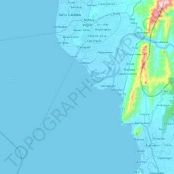
Nome: Mapa topográfico Vigan, altitude, relevo.
Local: Vigan, Ilocos Sur, Ilocos Region, 2700, Philippines (17.39422 120.20346 17.59134 120.43231)
Altitude média: 33 m
Altitude mínima: -1 m
Altitude máxima: 748 m
Faça uma doação
Outros mapas topográficos
Clique em um mapa para visualizar sua topografia, sua altitude e seu relevo.
Bantay
It has an average elevation of 100 meters (328.08 feet), with a land area of 7,660 hectares (18,900 acres). It is an elevated and hilly municipality but some barangays, especially those near creeks, are prone to flooding during heavy typhoons.
Altitude média: 8 m
Vigan
Vigan is situated in a Quaternary Age sedimentary plain called the Vigan-Bantay Plain which is part of the Ilocos coastal plain. The Vigan-Bantay Plain is bounded on the east by a moderately rugged Miocene sediments consisting of interbedded sandstones and shale to very rugged Meta-volcanics and Meta sediment…
Altitude média: 63 m
Faça uma doação
Faça uma doação
Santa
The topography of the municipality is undulating to rolling with slope ranging from 0-30%.
Altitude média: 75 m
Faça uma doação
Faça uma doação
Faça uma doação
Faça uma doação
Faça uma doação
Faça uma doação
Faça uma doação
Faça uma doação
Faça uma doação
Faça uma doação
Faça uma doação
Faça uma doação
Faça uma doação
Faça uma doação
Faça uma doação
Faça uma doação
Faça uma doação
Faça uma doação
Faça uma doação
Candon
Philippines > Ilocos Sur > Candon
Candon City is situated in the lower central portion of the Province of Ilocos Sur. It has a "C" shape with elevations ranging from 10 – 500 ft above sea level. The city is 346 kilometres (215 mi) from Metro Manila and 61 kilometres (38 mi) from Vigan City, the provincial capital.
Altitude média: 108 m
Faça uma doação
Faça uma doação
Faça uma doação
Faça uma doação