
Obrigado por apoiar este site ❤️
Faça uma doação
Faça uma doação
Mapa topográfico Doha
Clique no mapa para exibir a altitude.
Obrigado por apoiar este site ❤️
Faça uma doação
Faça uma doação
Doha
Doha is located on the central-east portion of Qatar, bordered by the Persian Gulf on its coast. Its elevation is 10 m (33 ft). Doha is highly urbanized. Land reclamation off the coast has added 400 hectares of land and 30 km (19 mi) of coastline. Half of the 22 km2 (8.5 sq mi) of surface area which Hamad International Airport was constructed on was reclaimed land. The geology of Doha is primarily composed of weathered unconformity on the top of the Eocene period Dammam Formation, forming dolomitic limestone.
Obrigado por apoiar este site ❤️
Faça uma doação
Faça uma doação
Sobre este mapa
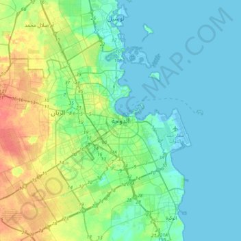
Nome: Mapa topográfico Doha, altitude, relevo.
Local: Doha, Qatar (25.12563 51.36642 25.44563 51.68642)
Altitude média: 12 m
Altitude mínima: -3 m
Altitude máxima: 48 m
Obrigado por apoiar este site ❤️
Faça uma doação
Faça uma doação